Knowledge of the ocean is limited because ice cover hampers observations.
Challenges:
The knowledge of physical and biological processes in the Arctic Ocean is limited, because the ice cover severely hampers observations, both in the upper layers and deep waters. A severe lack of in situ subsurface data for the Arctic Ocean calls for improving the ocean component of an integrated Arctic Observing System. INTAROS aimed to enhance the sensors and systems to extend data collection in both ice covered and open ocean areas.
Results from INTAROS:
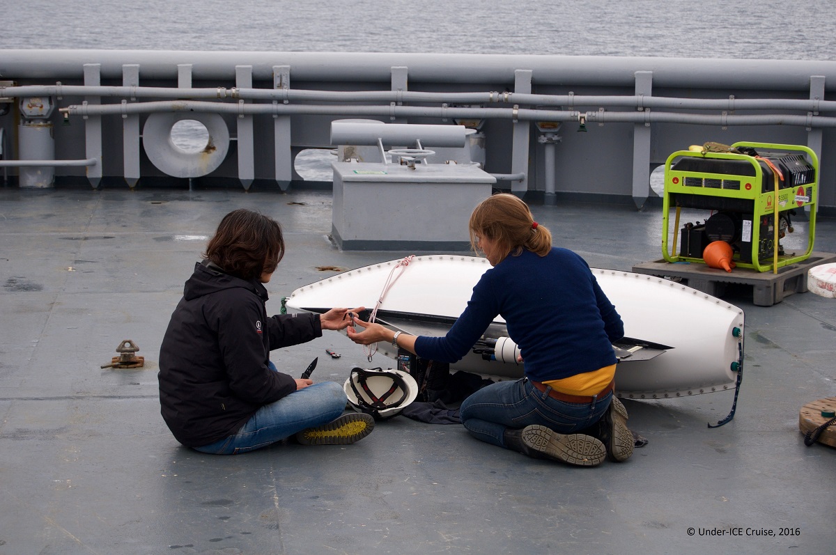
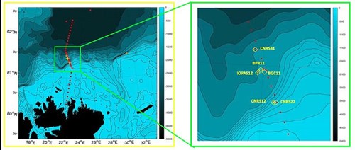
Oceanographically data have been collected in the central Arctic Ocean, north of Svalbard, in the Fram Strait and Kongsfjorden, in the Barents Sea, in coastal aras of Greenland and in Baffin Bay. North of Svalbard the observations of the Atlantic inflow to the Arctic Ocean and the dynamics of the boundary current have been strengthened using an array of oceanographic moorings. New moorings were installed along the INTAROS line at 22°E, covering the shelf break and the upper to middle continental slope (see map below). During three consecutive, one-year-long deployments in the 2017-2020 period, measurements by moored instruments were collected year-round and covered the entire subsurface water column. See plot of temperature time series below.
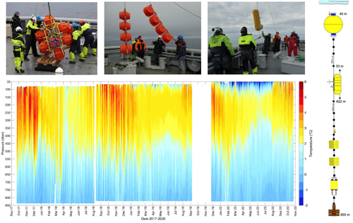
Figures: The photos on top are from the mooring operations north of Svalbard during the INTAROS cruise on the Norwegian Coast Guard Icebreaker KV Svalbard in August 2018. To the right is a drawing of a mooring with a a McLane profiler. The plot shows the time series of subsurface ocean temperature measured in 2017-2020 by a McLane profiler at the mooring located at the INTAROS line (22°E) north of Svalbard ( see map below). (Copyright: A. Beszczynska-Möller, IOPAN).
To add new in situ observations in the central Arctic Ocean, an ice-tethered IAOOS buoy was deployed for INTAROS by the Equipex IAOOS team on a drifting ice floe nearby the North Pole. The IAOOS buoy provided about a month of valuable physical ocean data (temperature, salinity, oxygen) down to the depth of 600 m, concomitant with atmospheric observations and high-resolution temperature measurements across air-snow-sea ice-ocean interfaces. Measurements with fixed moorings and drifting platforms were complemented with oceanographic sections with gliders, autonomous underwater vehicles profiling down to 1000 m in the ice-free areas of the northern Fram Strait.
Measurements of physical ocean parameters were also gathered by the INTAROS observing systems or platforms, principally dedicated to monitoring of biogeochemical or biological variables in the Arctic fjords or open ocean. The Ferrybox system on a ship of opportunity going between the northern Norway and Svalbard measured surface temperature and salinity along the ship's route in addition to data collection by novel sensors developed under INTAROS. New sensors were added under INTAROS to the AWIPEV observatory devoted to carbon system monitoring in Kongsfjorden It provides high-frequency (partially real-time) measurements of different parameters, including in situ temperature and salinity in the fjord. Long-term autonomous acoustic recordings were collected in the Kongsfjorden acoustic observatory, with the purpose of assessing the soundscape in an Arctic fjord with a special focus on anthropophony and biophony. INTAROS also contributed to implementation of the BGC Argo floats in the Baffin Bay that in addition to bio-optical and biogeochemical ocean properties provide profiles of standard physical ocean variables.
To improve the acquisition of seasonal ocean data in the marine component of the Greenland Ecosystem Monitoring program in Young Sound, NE Greenland new instruments were added to the existing moored array in the central fjord to measure new variables (fluorescence, turbidity, dissolved oxygen, and PAR) in addition to standard measurements of temperature and salinity. A new mooring was established in the inner fjord to resolve local variations and specifically to measure the impact of glacial run-off from the Greenland Ice sheet on freshening of the fjord waters. Two year-long times series of measured parameters were obtained, and the third deployment year is coming to an end, bringing another year of data. Additionally, during coastal cruises in West and East Greenland, the baseline carbonate system data (pH and OA) were collected in the upper ocean together with standard physical parameters at ~120 stations.
11-10-2021